Toolbox
Document management - the paperless office
Although the idea of a paperless office has been around since the beginning of the computer revolution, in reality it seemed to create even more paper. For historians with their love of documents, taking notes, etc, the concept of doing history digitally or paperless has seemed almost anathema. While some aspects of historical research have lent themselves to being digital - note-taking, databases - still there were/are the copious paper documents of photocopies, reports newsletters, journals, magazines.
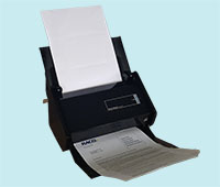 Ten years I purchased a document scanner (Fujitsu ScanSnap S510) and it was been an invaluable tool. I am now on my second model (ScanSnap xi5OO). The latest model is brilliant. Like its predecessor, it is quite small and can scan up to 25 pages per minute double sided. The quality is excellent so I scan reports, journals, letters , magazines - anything that is A4 size or smaller. I output as a PDF file.
Now that is great - but there's more. The software that comes with the scanner also does OCR (Optical Character Recognition) so any scanned text becomes searchable. Coupled with an indexing program it means that every document I have scanned is fully indexed.
So far less paper and almost everything that is scanned is indexed!
Bibliographic software
For a considerable time, I extolled the virtues of Biblioscape. It is still a very good stand alone Windows program that is not expensive. But I now use Zotero, is a project of the Corporation for Digital Scholarship and the Roy Rosenzweig Center for History and New Media.
Zotero is a great multi-purpose reference. It is designed to store, manage, and cite bibliographic references, such as books and articles. In Zotero, each of these references constitutes an item. More broadly, Zotero is a powerful tool for collecting and organizing research information and sources. At a most basic level, t can be used a catalogue for your library and reports.But one of its greatest benefits is collecting and managing references from sources such as Trove newspapers.
Another advantage is Zotero can be synced across devices including smartphones and tablets.
GIS software
GIS software has the potential to be a great tool for historians. Who hasn't had to prepare or include maps and diagrams for an article, book or report. The great drawback has been cost. The most well known and popular programs cost thousands and it is difficult to justify the cost. I've recently discovered a open source program called QGIS. The latest release is version 3 and it keeps getting better and better. It is extremely powerful with an active community developing upgrades, and comes with an impressive array of features.
Useful software
Some software that I have found extremely useful and productive
Autohotkey
Autohotkey began as a simple program as the name suggests for providing hotkeys and keyboard shortcuts. It does that and much more. I use keyboard shortcuts extensively for opening programs and abbreviations for commonly used words. For example I have shortcut for Alt X for swapping two letters. The beauty of autohotkey is that the shortcut can be used across all programs.
But Autohotkey is much more - a programming language that is quite powerful and useful for writing all sorts of small and versatile programs. I have written my own project management software and also a program for ingesting images. Very good forum with plenty of helpful advice.
Xplorer2
Xplorer2 is a great alternative to Windows Explorer. It is very flexible and layouts can be customised with dual panes, preview windows etc. Keyboard shortcuts can be customised. Xplorer2 can be used for FTP and renaming files.Listary
Listary is a small and slick program for locating files and folders by filename instantly for Windows. Works much better and much faster that the standard Windows program. Very handy and can be activated from Windows Explorer or Xplorer2.
Vuescan
Vuescan is a very versatile and powerful scanning program. Works with all scanners and numerous controls. There is a one-off payment for the professional version and a lifetime of updates for $79 but well worth it.Advanced File Renamer
Advanced Renamer is a very clever program that allows any possible way of renaming files and folders. From simply adding incremental numbers to files, adding random numbers or string, name of directory etc are possible solutions. With images, the renaming is even more extensive with including dpi, year, day and if GPS data is included, the city where the image was taken. Advanced Renamer also has special tags MP3 and Video files. A very useful program.
Image Resizer
Image Resizer for Windows is a very useful utiltiy for resiing images easily and quickly. While there are numerous ways of resizing images, this program is accessed by right click in Explorer and has various resize options. Simple to use and doesn't require opening up a program when a quick resize is needed.
Tick Tick
TickTick is a to do list, check list and task manager program. After experimenting with numerous to do programs, I have found this one suits my requirements the best. Plenty of features and cross-platform so syncs across desktop, web, phone and tablet. There is an annual fee but I think is worth the price.
ViceVersa Pro
ViceVersa Pro is a very powerful file backup and file synchronization program developed in Australia. Very flexible and works on the fly.